ALMA
Incorporated in 1873 after the discovery of rich silver ore in the Mosquito Range, the mountain community of Alma offers visitors many sites that reflect the early mining pioneer days, natural beauty, and recreation opportunties.
 At an elevation of 10,578 feet above sea level, Alma holds the distinction of being the highest incorporated municipality in North America. Worthwhile places to visit in the Alma area include the following:
- Listed on the State Register of Historic Properties, the 1935 Alma School is a rare local example of Mission-style buildings. It now serves as Alma's Town Hall and is open to the public during regular business hours.
- Also listed on the State Register, the 1936 Alma Community Church is a well preserved stone church of the Rustic Style.
- The 1871 Clesson Cabin was one of the first permanent residences in Alma. Originally built as the Stagestop.
- The Mosquito Range is graced with dozens of 19th Century mines that cling precariously to the steep slopes above each valley. It is also home to several rare plant species. Eighteen heritage sites west of Alma are interpreted in the Buckskin Gulch and Mosquito Pass historic auto tour brochures.
- The Bristlecone Pine Scenic Area above Alma protects a stand of wind-sculpted bristlecone pine trees, some of which are nearly a thousand years old.
- The 1894 Paris Mill, three miles west of Alma, was once an important site for processing precious metals. A Gold Arrastra in the same area, employed one man and his donkeys to grind gold-bearing ore.
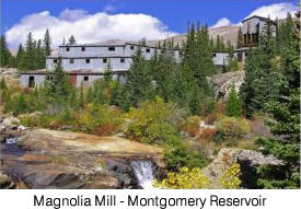
- The Magnolia Mill is a massive period structure at the inlet of Montgomery Reservoir near Alma. At the bottom of this reservoir lies the 1862 Montgomery town site.
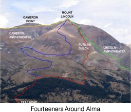
- The area offers hikers the opportunity to climb three Fourteeners in one day.
- There is no legal access to the summit of Mt. Bross and it is closed to the public.
Camping
- Kite Lake - 5.5 miles NW of Alma on County Road 8 (CR8). Campsites - Elevation 12,000 feet. Not recommended for trailers & RVs.
Driving Tours
- Mosquito Pass Historic Auto Tour - The Mosquito Pass Historic Auto Tour follows the old stage road (County Road 12) west to the summit of Mosquit Pass. Sign posts along the road correspond to nine historic sites that are interpreted in the auto tour brochure. Four-wheel drive is required beyond sign post 5. Auto tour brochures are available from the South Park Ranger District.
Fishing
- Upper Middle Fork - Three miles of stream access in the Pike National Forest above Montgomery Reservoir. Dense willows make for challenging fishing but this fast little creek supports good populations of brookies and cutthroats up to 14 inches. High clearance four-wheel drive vehicles are required on FR-408 btweeen the reservoir and Wheeler Lake.
- Montgomery Reservoir - Scenic mountain reservoir North of Alma. Stocked rainbows provide good shore fishing on the North and West sides. Bots are not allowed on the lake.
- Alma State Wildlife Area - About two miles of public stream access along County Road 4 between Montgomery Reservoir and Alma. Resident browns, brookies, and rainbows (6-14 inches) in the river and beaver ponds. This section of the Middle Fork is small and brushy.
- Mosquito Creek - Scenic creek and beaver ponds along Mosquito Pass Road (CR 12) West of Alma. Public access in the Pike National Forest at various points above the confluence with South Mosquito Creek. Browns and bookies up to 12 inches in the creek and beaver ponds. Please refer to the Pike National Forest map to avoid trespassing on private properties at various points throughout the valley, some of which are not posted or fenced.
- Middle Fork Easement - One mile of public stream access on the Middle Fork of the South Platte below Alma. Good small river fishing for wild browns and a few stocked rainbows up to 16 inches. Anglers must stay wihtin 20 feet of the banks to avoid private property.
Wildlife
- ALMA SWA - The 277-acre Alma State Wildlife Area is North of Alma along the Middle Fork of the South Platte River. Fishing, wildlife viewing, and camping are available in accordance with state fishing regulations, and restrooms and campsites are provided. To reach the State Wildlife Area, go 1.5 miles North from Alma on Highway 9, then turn left on County Road 4. The area will be 0.25 miles down the road on your left.
Trails
| Trail # |
Trail Name |
Usage |
Length |
Environment |
Trail Features |
| 3 - 14ers |
14ers Trail |
TH, HK |
3.4 miles |
Alpine |
Steep hiking trail up Mt. Democrat & Mt. Lincoln from
Kite Lake trailhead. Also access to Mt. Cameron |
| FR-856 |
Buckskin Basin Road |
4WD, OHV, HK |
2 miles |
Alpine, Stream |
Rocky road to Buckskin Basin |
| FR-192 |
Buckskin Joe Road |
4WD, OHV, MB |
1 mile |
Forest |
Forest Road connection from CR-8 to FR-450 |
| FR-452 |
Cooney Lake Road |
4WD, HK |
0.7 miles |
Alpine |
Rocky road to Cooney Lake |
| CR-8 |
Kite Lake |
SUV, MB |
3 miles |
Meadow, Stream, Alpine |
Access to Kite Lake trailhead & campground |
| FR-450 |
Loveland Mountain Road |
4WD, OHV, HK |
3.5 miles |
Forest, Alpine |
Steep road switchbacks up Loveland Mountain from FR-192 |
| CR-12 |
Mosquito Pass |
4WD, MB |
4.9 miles |
Meadow, Alpine |
Rocky road beyond maintained gravel section |
| FR-449 |
Narrow Gauge |
HK, MB, EQ |
2.5 miles |
Forest |
Gentle forest road follows old railroad grade |
| FR-437 |
Quartzville Road |
4WD, OHV, MB |
2 miles |
Alpine |
Steep road climbs up to Cameron Amphitheater |
| FR-857 |
Switchback Road |
4WD, OHV, HK |
2 miles |
Alpine |
Rocky road with steep switchbacks |
| FR-408 |
Wheeler Lake |
4WD, OHV, MB, HK |
4.5 miles |
Meadow, Stream, Alpine |
Steep & very rocky, 4WD road to Wheeler Lake,
4WD & high clearance required |
| CR-787 |
Windy Ridge |
SUV, 4WD, MB |
3.4 miles |
Forest, Alpine |
Scenic road - CR8 to Dolly Varden Creek |
TRAIL GUIDE KEY
Route Number Key (Route numbers may differ on various maps)
CR = County Road (asphalt or gravel surface suitable for passenger vehicles)
FR = Forest Road (improved dirt roads, two-track roads, and high clearance 4WD roads)
FT = Forest Trail (single track trail, includes bother motorized and non-motorized vehicles)
Suggested Use Key - Suggested uses are based on user feedback and US forest Service Travel restrictions. Road and Trail restrictions are subject to change over time.
SC = Seasonal Closure (generally between January 1st and early June of each year)
TH = Trailhead (parking area)
HK = Hiking
BP = Backpacking
MB = Mountain Biking
EQ = Equestrian or pack animal use
4WD = Highway-legal vehicles with high clearance and 4-wheel drive capability
OHV = Off-highway vehicles that are not highway legal (four-wheelers, ATVs, and dirt bikes)
MC = Motorcycles (dirt bikes)
PC = Passenger Cars
CG = Campground
Notice: Many of the roads and trails described above are closed on a seasonal basis to protect wildlife. Please respect all closures and stay on designated routes to prevent resource damage.