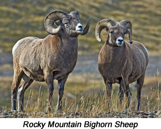
GRANT

Colorado Trail Marker on Kenosha Pass
  • Founded in 1870 at an elevation of 8,606 feet.

  • The nearby Colorado Trail is Colorado's premier long-distance trail, stretching 486 miles from Denver to Durango.  The route passes over the top of Kenosha Pass, amongst peaks with lakes, creeks, and diverse ecosystems.

  • Early ranchers in the Grant area opened up their homes to provide food and lodging for the thousands of gold and silver prospectors and early settlers passing through the area.

  • One such rancher was Charles Hepburn, who along with his wife Agnes Wood Hepburn, established the Kenosha House near the top of Kenosha Pass in 1865, as well as a stagecoach way station at their nearby ranch.  In a trip through Park County in 1868, vice-presidential candidate Schuyler Colfax was their guest.

  • He, along with running mate, Ulysses S. Grant won the election later that year.

  • When a post office was established in the area in 1870, the Hepburns named the town Grant, after the President.

  • Once a thriving railroad stop, nearly all the original buildings of the early days are gone from Grant.

  • The Guanella Pass Road, between Grant and Georgetown in Clear Creek County, is designated a National Scenic Byway.  The 22-mile-long paved route climbs above the tree line and dips into deep forests on both sides of the pass.  Visitors can explore the road in passenger vehicles, on bycycles, or on foot from the numerous trailheads along the pass.


Camping

  • Burning Bear - 4 miles NW of Grant via Park County Road 62.  13 campsites; max trailer length 20 feet; elevation 9,800 feet
  • Geneva Park - 5.2 miles NW of Grant via Park County Road 62.  26 campsites; max trailer length 20 feet; elevation 9,800 feet
  • Hall Valley - 6 miles NW of Grant via US Hwy 285 & Park County Road 60.  9 campsites; max trailer length 20 feet; elevation 9,900 feet
  • Handcart TT - 6 miles NW of Grant via US Hwy 285 & Park County Road 60.  11 campsites; no trailers allowed; elevation 9,800 feet


Driving Tours

  • Guanella Pass Scenic & Historic Byway - Follows an old wagon trail used by miners traveling between Georgetown and Grant.  Gold lured miners and others to the area, but it was silver that brought prosperity to the valley.  Today, visitors may explore this 22-mile historic route by car, and/or hike the many area trails.


Ricky Mountain Bighorn Sheep

Fishing

  • Beaver Creek - Small, brushy stream parallels Forest Road 123 in the Pike National Forest west of Grant.  Creek and beaver ponds hold abundant small brookies.
  • Wilderness on Wheels - Located west of Grant on US Hwy 285, a mile-long boardwalk provides nature access to peiople of all abilities, their families, and caregivers.  Protions of the boardwalk facilitate fishing access for brookies along the North Fork of the South Platte River.  Just upstream is a spring-fed pond where disabled and senior citizens can fish for stocked rainbows.  The facility also has accessible forest cabins, huts, and tent sites.


Ricky Mountain Bighorn Sheep

Wildlife

Rocky Mountain Bighorn Sheep - Travelers approaching Grant in the cold months are very likely to have a chance to meet the herd who love to lick the winter salt from the roadway and slow down the traffic heading for the ski areas.  While they appear docile, the sheep prefer a hands-off approach, though they will tolerate photographers working from inside vehicles.
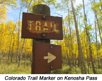


Trails

Trail # Trail Name Usage Length Environment Trail Features
FT-635 Three Mile Creek HK, BP, EQ 6.5 miles Forest, Alpine Wilderness Access
FT-602 Abyss Lake HK, BP, EQ 8 miles Forest, Alpine Lake Access
FT-601 Burning Bear HK, EQ 5.5 miles Dense Forest Historic Sites
FT-633 Gibson Lake HK 2.5 miles Forest, Alpine Lake Access
FR-565 Red Cone MB, OHV 6 miles Alpine Steep Two-Track Road
FT-600 South Park HK, EQ 11.7 miles Dense Forest Back Country Access
FR-121 Webster Pass MB, OHV 5 miles Forest, Alpine 4WD Area

TRAIL GUIDE KEY

Route Number Key (Route numbers may differ on various maps)

CR = County Road (asphalt or gravel surface suitable for passenger vehicles)
FR = Forest Road (improved dirt roads, two-track roads, and high clearance 4WD roads)
FT = Forest Trail (single track trail, includes bother motorized and non-motorized vehicles)

Suggested Use Key - Suggested uses are based on user feedback and US forest Service Travel restrictions.  Road and Trail restrictions are subject to change over time.

SC = Seasonal Closure (generally between January 1st and early June of each year)
TH = Trailhead (parking area)
HK = Hiking
BP = Backpacking
MB = Mountain Biking
EQ = Equestrian or pack animal use
4WD = Highway-legal vehicles with high clearance and 4-wheel drive capability
OHV = Off-highway vehicles that are not highway legal (four-wheelers, ATVs, and dirt bikes)
MC = Motorcycles (dirt bikes)
PC = Passenger Cars
CG = Campground

Notice:  Many of the roads and trails described above are closed on a seasonal basis to protect wildlife.  Please respect all closures and stay on designated routes to prevent resource damage.