Trails
| Trail # |
Trail Name |
Usage |
Length |
Environment |
Trail Features |
| CR-94 |
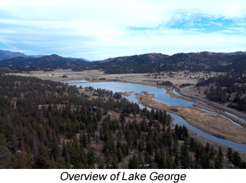
County Road 94 |
PC, SUV |
1.9 miles |
Forest, Meadow |
Connects with Teller County Road 32 northeast of Lake George |
| CR-96 |
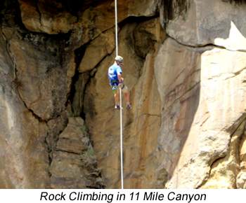
Eleven Mile Canyon Rd |
PC, SUV |
9.6 miles |
Forest, Canyon, Stream |
Narrow road follows the South Platte River for 9.6 miles; camping, fishing, & rock climbing |
| CR-112 |
Happy Meadows Rd |
PC, SUV |
2.1 miles |
Forest, Meadow, Stream |
County road access to Happy Meadows Campground & the South Platte River |
| FT-619 |
Longwater |
HK |
3.5 miles |
Forest, Stream |
Trail starts on FR-210 & switchbacks to Tarryall Creek & the South Platte River |
| FT-654 |
Platte River |
TH, HK |
2.5 miles |
Forest, Stream |
Trail starts at the end of CR-112 & follows the South Platte River |
| FT-626 |
Platte Springs |
TH, HK |
1.6 miles |
Forest, Stream |
Trail starts on FR-210 & dead ends at South Platte River for hike-in fishing |
| FR-210 |
Platte Springs Rd |
TH, 4WD, OHV |
1.7 miles |
Forest, Meadow |
High clearance forest road provides access to FT-619 & FT-626 |
| FR-393 |
Wagon Tongue Rd |
2WD, OHV |
4.7 miles |
Forest, Canyon |
4WD road from CR-98 down to CR-96 in Eleven Mile Canyon |
TRAIL GUIDE KEY
Route Number Key (Route numbers may differ on various maps)
CR = County Road (asphalt or gravel surface suitable for passenger vehicles)
FR = Forest Road (improved dirt roads, two-track roads, and high clearance 4WD roads)
FT = Forest Trail (single track trail, includes bother motorized and non-motorized vehicles)
Suggested Use Key - Suggested uses are based on user feedback and US forest Service Travel restrictions. Road and Trail restrictions are subject to change over time.
SC = Seasonal Closure (generally between January 1st and early June of each year)
TH = Trailhead (parking area)
HK = Hiking
BP = Backpacking
MB = Mountain Biking
EQ = Equestrian or pack animal use
4WD = Highway-legal vehicles with high clearance and 4-wheel drive capability
OHV = Off-highway vehicles that are not highway legal (four-wheelers, ATVs, and dirt bikes)
MC = Motorcycles (dirt bikes)
PC = Passenger Cars
CG = Campground
Notice: Many of the roads and trails described above are closed on a seasonal basis to protect wildlife. Please respect all closures and stay on designated routes to prevent resource damage.