JEFFERSON

  • Founded in 1879 at an elevation of 9,501 feet.

  • The ranching town of Jefferson was established when the DSP&P Railroad arrived in 1879.  A railroad depot was built soon after, and by 1881 the town had two butcher shops, a saloon, lumber mill, hotel, blacksmith, post office, express office, and a population of 300.

  • Ricky Mountain Bighorn Sheep
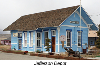
  • Listed on the National Register of Historic Places, the Jefferson Depot is a well preserved, wood frame railroad depot on US Hwy 285 in Jefferson.

  • Jefferson is the northernmost point on the Tarryall Valley Scenic & Historic Auto Tour, a 43-mile two-lane paved road that follows County Road 77 (Tarryall Road) to Lake George.

  • The Jefferson Schoool is listed as a Park County Historic Landmark and has been a center of activity since its construction in 1901.  It continues to serve as a community center and church on Main Street.

  • Following a rough wagon road west from Denver, the DSP&P Railroad arrived at Kenosha Pass Summit in 1879.  Listed on the State Register of Historic Properties, this site is important for its association with the DSP&P Railroad's crossing of Kenosha Pass.  Visit the roadside exhibit on the east side of the road or walk the restored rail bed at this interpretive site.

  • The historic Wahl Ranch unfolds as one descends into South Park over Kenosha Pass.  This National Register District encompasses several remaining log and wood frame buildings dating from 1883 to 1948.

  • The Tarryall National Historic Landscape District encompasses the land along the Tarryall Road (CR77) from Jefferson to near Lake George.  This landscape district is one of the first of its kind in the state, and the traveler can sense the feeling of living the life of the homesteaders who settled along this valley in the early 1860s.  Besides breathtaking scenery, the traveler may spot buffalo, antelope, mountain lions, bobcats, deer, and may need to stop for cattle on the road through this open range.


Camping

  • Jefferson Creek - 5 miles North of Jefferson off CR35 & CR37.  17 campsites; max trailer length 25 feet; elevation 10,100 feet
  • Lodgepole - 4 miles North of Jefferson off CR35 & CR37.  34 campsites; max trailer length 30 feet; elevation 9,900 feet
  • Aspen - 4 miles North of Jefferson off CR35 & CR37.  12 campsites; max trailer length 25 feet; elevation 9,900 feet


Driving Tours

  • Tarryall Valley Tour - Tarryall Road (County Road 77) provides a very scenic auto tour between Jefferson and Lake George.  This valley also contains 32 sites that are eligible for listing on the National Register of Historic Places.  Roadside exhibits interpret seven notable sites along the route.  Please contact the Park County Tourism Office (719-836-4298) for a copy of the Tarryall Valley tour brochure.


Fishing

  • Jefferson Lake - Provides access for fishing and hiking.  The State of Colorado stocks Jefferson Lake with rainbow trout.  The lake is surrounded by scenic mountains.  A stream and a small brook enter the lake on the far side.  Jefferson Lake is a very popular area with picnic tables and restrooms.
  • Jefferson Creek - Small, brushy stream and beaver ponds contain small brookies along County Road 37 northwest of Jefferson.  Forest Trail #643 provides back country fishing access for even smaller brookies along West Jefferson Creek.
  • Michigan Creek - Limited public fishing access at Michigan Creek Campground on County Road 54 northwest of Jefferson.  Browns and brookies up to 12 inches.
  • Tarryall Reservoir - Managed by Colorado Parks & Wildlife, this smalll reservoir is seasonally productive for rainbows, browns, and pike.  Anglers may fish from shore, small boat, or float tube.  Free camping and picnic facilities are provided around the lake.  The inlet area is seasonally good for migratory bird watching and waterfowl hunting.


Wildlife

  • Teter (Michigan Creek) State Wildlife Area - Brushy creek along County Road 35 west of Jefferson.  Meandering stream with deep pools and beaver ponds harbor numerous browns up to 16 inches.  Nearly two miles of public water receives relatively little use.
  • Tarryall State Wildlife Area - About one mile of public stream access above Tarryall Reservoir along County Road 77.  Fair for resident browns up to 15 inches.  Larger trout migrate upstream annually from Tarryall Reservoir.  Aquatic habitat was improved several years ago through a Colorado Parks & Wildlife stream enhancement project.


Trails

Trail # Trail Name Usage Length Environment Trail Features
FT-1776 Colorado Trail HK, MB, EQ 11 miles Diverse Scenic Trail
FT-643 West Jefferson HK, BP 3.5 miles Forest, Meadow Continental Divide

TRAIL GUIDE KEY

Route Number Key (Route numbers may differ on various maps)

CR = County Road (asphalt or gravel surface suitable for passenger vehicles)
FR = Forest Road (improved dirt roads, two-track roads, and high clearance 4WD roads)
FT = Forest Trail (single track trail, includes bother motorized and non-motorized vehicles)

Suggested Use Key - Suggested uses are based on user feedback and US forest Service Travel restrictions.  Road and Trail restrictions are subject to change over time.

SC = Seasonal Closure (generally between January 1st and early June of each year)
TH = Trailhead (parking area)
HK = Hiking
BP = Backpacking
MB = Mountain Biking
EQ = Equestrian or pack animal use
4WD = Highway-legal vehicles with high clearance and 4-wheel drive capability
OHV = Off-highway vehicles that are not highway legal (four-wheelers, ATVs, and dirt bikes)
MC = Motorcycles (dirt bikes)
PC = Passenger Cars
CG = Campground

Notice:  Many of the roads and trails described above are closed on a seasonal basis to protect wildlife.  Please respect all closures and stay on designated routes to prevent resource damage.